
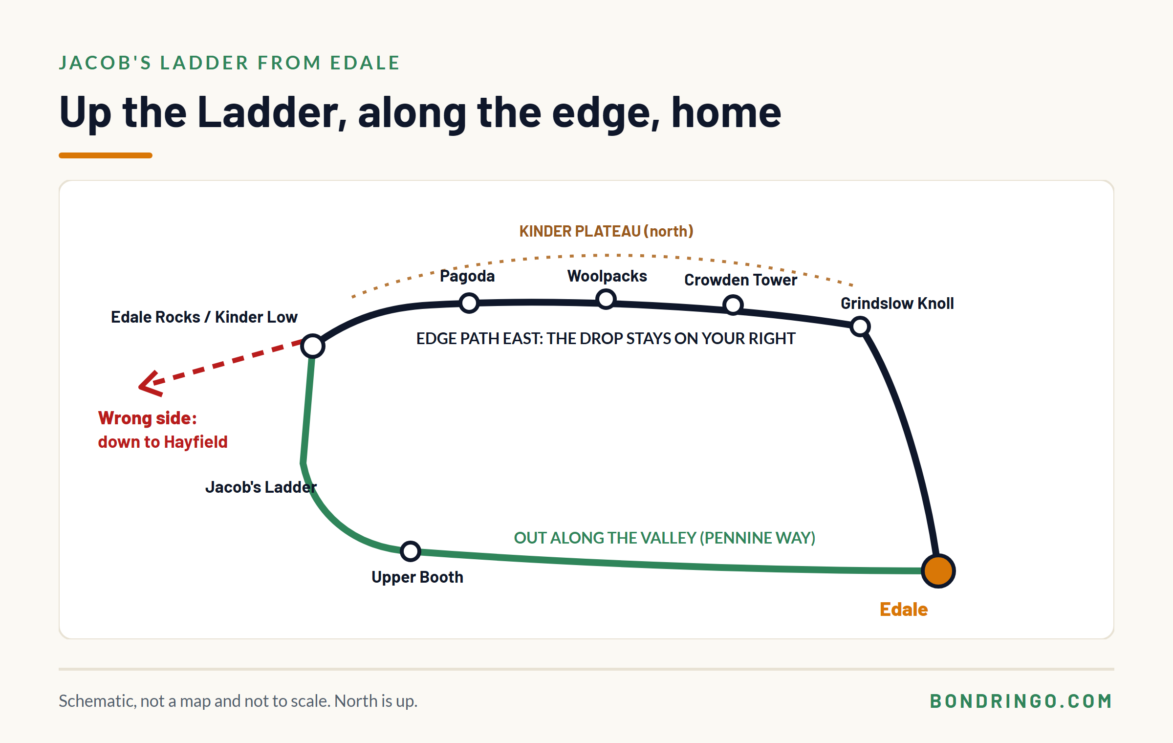
Jacob’s Ladder is the stone-stepped path that climbs from the head of the Edale valley onto the south-western corner of Kinder Scout. It’s an old packhorse route and part of the Pennine Way, and it’s the gentlest way up onto Kinder from Edale. Most people walk it as a loop: out along the valley through Upper Booth, up the Ladder, along Kinder’s southern edge past the Woolpacks, and back down to Edale.
Getting up is the easy part. The navigation that matters comes at the top, where several paths meet on broad, flat ground and, in cloud, one wrong turn sends you down the far side of the hill towards Hayfield instead of back to Edale.
So this guide goes through the walk stage by stage, with the most time spent on the bit the route listings skip: the way off the top.
How long is the Jacob’s Ladder walk from Edale?
It depends on the loop you choose. Route guides put the common circuits at roughly 6 to 10 miles, depending on whether you start at Edale village or Upper Booth, how far along Kinder’s edge you go, and which way you come down.
| Start | Edale station or village, or the car park near Upper Booth |
| The climb | Jacob’s Ladder, on the Pennine Way |
| At the top | Edale Rocks, with the Kinder Low trig point close by |
| Usual return | East along Kinder’s southern edge, then down a clough or Grindslow Knoll |
| Distance | Roughly 6 to 10 miles, depending on the loop |
| Map | OS Explorer OL1, The Dark Peak |
| Best for | A first trip onto Kinder in clear weather |
The walk in four stages
1. Along the valley to the foot of the Ladder
From Edale, the Pennine Way heads west along the valley to Upper Booth and on towards the head of the valley. It’s gentle, well signed and on good paths.
The decision: none really, which makes it the place to set your timings. Note when you leave Edale and when you reach the foot of the Ladder, and you’ve got a real pace for the day rather than a guess.
Never Feel Lost Again: The Free UK Navigation & Safety Pack
Stop relying solely on a fragile phone battery. Download the exact tools a professional outdoor instructor uses to stay safe in the British hills.

Enter your email below to get instant access to:
- NEW: The Hike Planning & Safety Checklist: A comprehensive pre-walk checklist to ensure you never leave a critical item behind or rely purely on a smartphone.
- The Emergency Protocol Guide: A highly structured, zero panic system detailing exactly what to do if lost on Dartmoor/Scottish hills, including when and how to call Mountain Rescue.
- The OS Map & Navigation Cheat Sheet: A quick reference guide to decoding complex map symbols and plotting grid references when your mind goes blank.
- The Route Card Template: The exact, logic-driven framework I use to plan foolproof expeditions and identify safe escape routes before leaving the house.
- The Timing Crib Card: Never misjudge daylight again. Master the mathematics of measuring pacing distance and timings for steep ground.
2. Up Jacob’s Ladder
At the head of the valley the path crosses the stream and climbs Jacob’s Ladder, a steep, stone-pitched path that zig-zags up the hillside.
The decision: take the steps steadily. It’s the steepest part of the day, but it’s short, and the path is obvious.
3. The top: Edale Rocks and Kinder Low
Above the Ladder, the path levels out onto broad, open ground near Edale Rocks, with the Kinder Low trig point a short walk away. This is where the walk changes.
In clear weather it’s obvious where everything is. In cloud, you’re on wide, flat ground where several paths meet: the Pennine Way carrying on north across the plateau, routes heading west and down towards Hayfield, and the edge path heading east along Kinder’s southern rim, back towards Edale.
This is the decision that matters most, and it gets its own section below.
4. East along the southern edge, and down
The usual way back follows Kinder’s southern edge east, past the weathered gritstone of the Pagoda, the Woolpacks and Crowden Tower, towards Grindslow Knoll. From there you drop back to Edale, down Crowden Clough, Grindsbrook Clough or the path off Grindslow Knoll. In heavy rain, the cloughs mean wet rock and a rising stream, so the Grindslow Knoll path is often the better way down.
The decision: keep the edge as your handrail. Walking east along the southern edge, the drop into the Edale valley stays on your right. If it isn’t, stop and work out why before going any further.
How do you navigate off Kinder Low in cloud?
Here’s the problem. The top of Jacob’s Ladder and Kinder Low sit on broad, flat ground. The contours go quiet, the paths are worn and braided, and some of the paths printed on the map have eroded away. In cloud, everything looks the same in every direction.
And the ground falls away on more than one side. Go wrong here and you can drop off the west side, which leads down towards Hayfield and the Kinder Reservoir, not back to Edale. The paths down that side are real and well used, which is exactly why it’s an easy mistake.
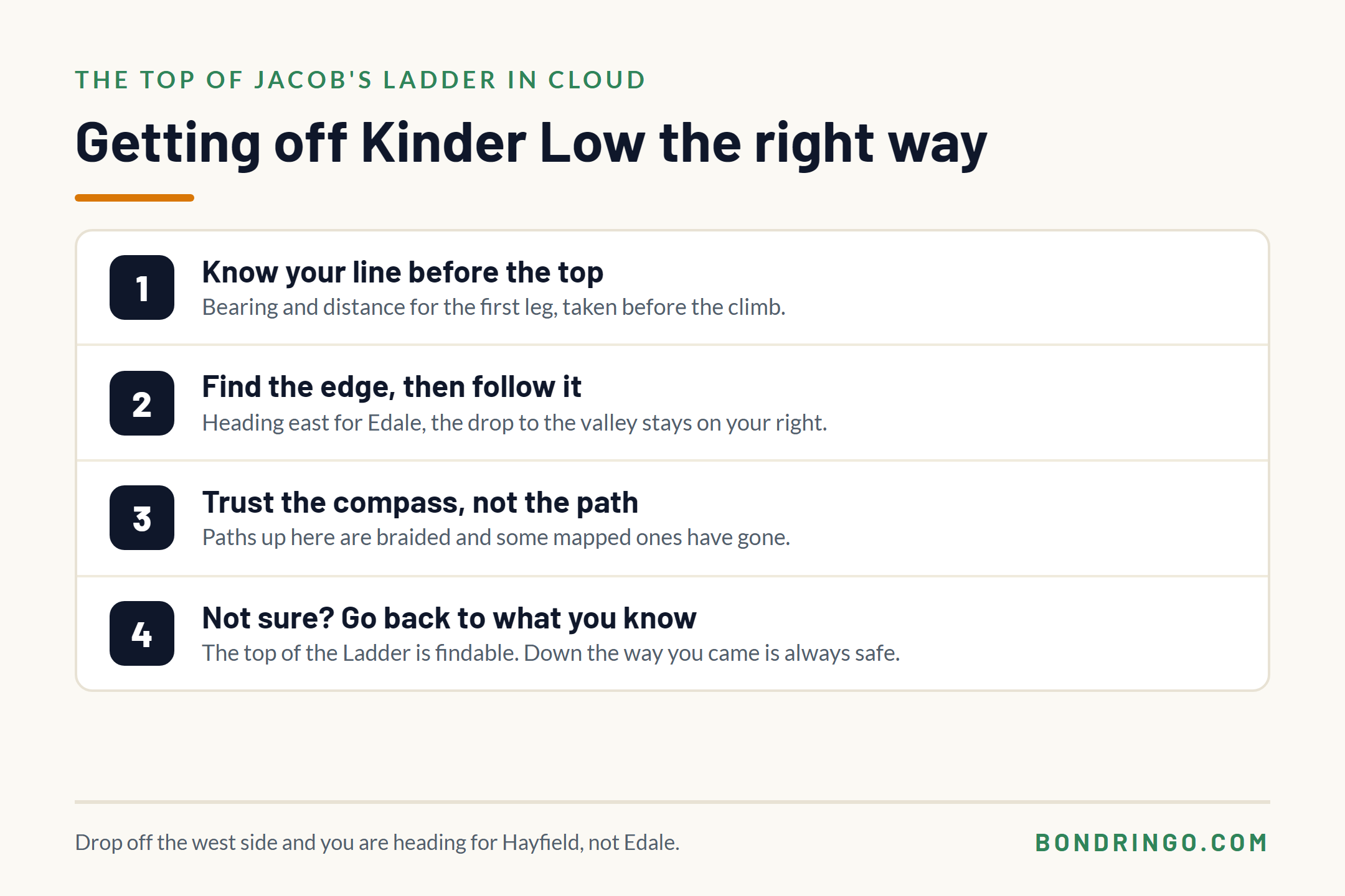
Four things keep you right:
- Know your line before you reach the top. Decide at the foot of the Ladder which way you’re going off, and take the bearing for the first leg at home or before the climb, not on the plateau in a gale. Allow for magnetic declination if your map says it’s needed, and note the distance too, so you can walk the leg by compass, pacing and timing.
- Find the edge, then follow it. For the way back to Edale, you want the southern edge heading east. Once you’re on it, the drop to the valley on your right is your check.
- Use the compass, not the path. On braided paths in cloud, the path you’re on may not be the one you think. Check your direction against the compass every few minutes.
- If you’re not sure, go back to what you know. The top of Jacob’s Ladder is a fixed, findable point. Retracing your steps down the Ladder is always a safe way off.
Our guide to walking from Edale station goes deeper into why Kinder’s plateau is so much harder in cloud than it looks on the map, and how to use the edges.
Can you walk Jacob’s Ladder by train?
Yes, and it’s one of the easiest hill walks in England to do without a car. Edale station is on the Hope Valley line between Manchester and Sheffield, and the walk starts from the village a few minutes from the platform. Our Peak District by train guide covers the line and the other walks from Edale and Hope.
One thing to watch: if you drop off the west side of Kinder by mistake, you’re heading for Hayfield, on the other side of the hill from the station. Another reason to get the top right.
Plan backwards from the second-to-last train home, and give yourself a margin, because the plateau can be slower than the map suggests. What to do if you miss the last train off the hill covers the rest.
Is Jacob’s Ladder hard?
The climb itself is steep but short, on a good stone path. In clear weather, the whole loop is a straightforward hill day for anyone with reasonable fitness.
What makes it harder is the weather on top. Kinder is high, exposed moorland, and in cloud the navigation off Kinder Low is a genuine test. Pick a clear day for your first time, and save the cloudy version for when you’re confident with a compass.
Frequently Asked Questions
How long does the Jacob’s Ladder walk take?
Route guides put the common loops from Edale or Upper Booth at roughly 6 to 10 miles, so most people take somewhere between half a day and a full day, depending on the loop, the weather and how long they stop. Allow extra time if any of it is in cloud, because navigating on the plateau is slower.
Where does Jacob’s Ladder start?
At the head of the Edale valley, beyond Upper Booth, on the Pennine Way. Most walkers reach it from Edale village, walking west along the valley, or from the car park near Upper Booth.
Is Jacob’s Ladder part of the Pennine Way?
Yes. The Pennine Way starts in Edale and climbs onto Kinder Scout by Jacob’s Ladder, an old packhorse route, before heading north across the plateau.
What is at the top of Jacob’s Ladder?
Broad, open ground near Edale Rocks, with the Kinder Low trig point a short walk away. Several paths meet here, including the Pennine Way north and the edge path east along Kinder’s southern rim, which is the usual way back towards Edale.
Can you get lost on Kinder Scout?
Yes, especially in cloud. The plateau is broad and flat, the contours tell you little, some mapped paths have eroded away and the ground falls away on more than one side. Know your line before you reach the top, use the compass, and follow the edges, which are the most reliable features up there.
Before you go
Pick a clear day for your first time up, mark your way off Kinder Low on the map tonight, and know which way the edge path runs before you start the climb. Carry the paper map and compass, a head torch and a warm layer, and register your phone for 999 texts, because signal on Kinder is patchy. If your phone is part of how you navigate, our free Digital Safety Net course sets it up properly as a backup to the map and compass. Ask any questions in the comments below.


